Millions of Americans to Face Severe Weather Risks Through Tuesday
Posted by Temmy
Tue, May 04, 2021 9:12am
The first week of May is beginning quite active on the severe weather front, with hundreds of millions of Americans across the eastern half of the nation at risk for dangerous thunderstorms.
The severe weather dangers on Monday and Tuesday follow an outbreak of tornadoes across Mississippi to end the weekend, including one large nighttime tornado that struck the city of Tupelo. Potent storms with hail, damaging winds and a few tornadoes were also reported across Colorado's Front Range and the central Plains Sunday.
Forecasters expect the storms early this week to pose similar hazards over much broader and even more populated areas.
Even outside of the areas that AccuWeather meteorologists are zeroing in on for more concentrated severe weather risks, any thunderstorm across the Central and Eastern states could turn heavy and gusty on the local level early this week.
Several disturbances high in the atmosphere, coupled with warm, humid air out of ahead of these systems, will be the catalyst for the widespread downpours and thunderstorms anticipated.
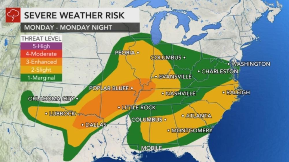
Late Monday into Monday night, a system ejecting out of the Rockies is expected to fire up severe thunderstorms from eastern Oklahoma into southern Missouri and northern Arkansas. The threat is forecast to extend into the lower Ohio Valley.
"These severe thunderstorms are expected to bring large hail, intense lightning, flash flooding and damaging wind gusts, with an AccuWeather Local StormMaxâ„¢ of 80 mph," AccuWeather Meteorologist Nicole LoBiondo said, adding that tornadoes would also be possible.
Larger metro areas such as Little Rock, Arkansas; St. Louis and Indianapolis could be in the crosshairs of these dangerous thunderstorms.
AccuWeather meteorologists are urging residents to make sure they have a way to receive severe weather warnings before heading to bed, as the risk of severe weather is expected to continue well after dark.
"Even outside of the main severe weather threat zone, locally dangerous storms and isolated tornadoes can occur in the Southeast states," AccuWeather Senior Meteorologist Alex Sosnowski said.
"Severe thunderstorms, including isolated tornadoes, can occur in the swath from central Alabama through central and northern Georgia, middle and upstate South Carolina and part of North Carolina into Monday evening," Sosnowski added.
Atlanta is among the southern U.S. cities at risk for dangerous thunderstorms, including tornadoes, into Monday evening. During the midmorning hours Monday, radar indicated debris within a tornado-warned thunderstorm just southwest of Atlanta. Radar-indicated debris is a tell-tale sign of a tornado on the ground.
Monday afternoon brought additional tornado-warned thunderstorms in Georgia, as well as in the Carolinas. AccuWeather forecasters urged people to stay vigilant even after one storm hits. More than one severe storm could target some locations in the Southeast into the evening.
"Some communities can be hit by more than one severe thunderstorm and could be under more than one tornado warning into the evening hours," Sosnowski said.
Experts say yet another round of dangerous weather will erupt Tuesday.
A surge of very humid air expanding northward through the Gulf states will collide with a storm moving up along a front from east Texas to the Ohio Valley. This will result in an outbreak of thunderstorms that will likely linger well into Tuesday night, according to AccuWeather Senior Meteorologist Brett Anderson.
The thunderstorms are expected to target cities such as Baton Rouge, Louisiana; Jackson, Mississippi; Nashville; Birmingham and Montgomery, Alabama; Atlanta; and potentially more northern areas as well such as Louisville, Kentucky; Charleston, West Virginia; and Pittsburgh. Tupelo and other Mississippi towns that were devastated by Sunday's tornadoes will be right in the middle of the threat zone.
Storm hazards will include hail, flooding downpours, tornadoes and damaging, straight-line wind gusts with an AccuWeather Local StormMaxâ„¢ of 75 mph, according to LoBiondo.
"There will also be pockets of flash flooding, especially in low-lying and poor drainage areas, but fortunately the storms will be moving along at a decent clip, which will limit the duration of intense rainfall for most areas," Anderson said.
Areas of the South that experienced a very wet month of April will be at greatest risk of experiencing flash flooding issues.
Those with travel plans on the road and in the air across the Central, Eastern and Southern states can anticipate a slow-go amid the stormy pattern.
Even without any flooding problems, the torrential downpours within the storms can lead to problems for motorists in the form of reduced visibility on the interstates as well as an increased risk of hydroplaning.
Thunderstorms packing large hail could stir up more tornadoes across the South as the severe pattern shifts eastward.
The first week of May is beginning quite active on the severe weather front, with hundreds of millions of Americans across the eastern half of the nation at risk for dangerous thunderstorms.
The severe weather dangers on Monday and Tuesday follow an outbreak of tornadoes across Mississippi to end the weekend, including one large nighttime tornado that struck the city of Tupelo. Potent storms with hail, damaging winds and a few tornadoes were also reported across Colorado's Front Range and the central Plains Sunday.
Forecasters expect the storms early this week to pose similar hazards over much broader and even more populated areas.
Even outside of the areas that AccuWeather meteorologists are zeroing in on for more concentrated severe weather risks, any thunderstorm across the Central and Eastern states could turn heavy and gusty on the local level early this week.
Several disturbances high in the atmosphere, coupled with warm, humid air out of ahead of these systems, will be the catalyst for the widespread downpours and thunderstorms anticipated.
Late Monday into Monday night, a system ejecting out of the Rockies is expected to fire up severe thunderstorms from eastern Oklahoma into southern Missouri and northern Arkansas. The threat is forecast to extend into the lower Ohio Valley.
"These severe thunderstorms are expected to bring large hail, intense lightning, flash flooding and damaging wind gusts, with an AccuWeather Local StormMaxâ„¢ of 80 mph," AccuWeather Meteorologist Nicole LoBiondo said, adding that tornadoes would also be possible.
Larger metro areas such as Little Rock, Arkansas; St. Louis and Indianapolis could be in the crosshairs of these dangerous thunderstorms.
AccuWeather meteorologists are urging residents to make sure they have a way to receive severe weather warnings before heading to bed, as the risk of severe weather is expected to continue well after dark.
"Even outside of the main severe weather threat zone, locally dangerous storms and isolated tornadoes can occur in the Southeast states," AccuWeather Senior Meteorologist Alex Sosnowski said.
"Severe thunderstorms, including isolated tornadoes, can occur in the swath from central Alabama through central and northern Georgia, middle and upstate South Carolina and part of North Carolina into Monday evening," Sosnowski added.
Atlanta is among the southern U.S. cities at risk for dangerous thunderstorms, including tornadoes, into Monday evening. During the midmorning hours Monday, radar indicated debris within a tornado-warned thunderstorm just southwest of Atlanta. Radar-indicated debris is a tell-tale sign of a tornado on the ground.
Monday afternoon brought additional tornado-warned thunderstorms in Georgia, as well as in the Carolinas. AccuWeather forecasters urged people to stay vigilant even after one storm hits. More than one severe storm could target some locations in the Southeast into the evening.
"Some communities can be hit by more than one severe thunderstorm and could be under more than one tornado warning into the evening hours," Sosnowski said.
Experts say yet another round of dangerous weather will erupt Tuesday.
A surge of very humid air expanding northward through the Gulf states will collide with a storm moving up along a front from east Texas to the Ohio Valley. This will result in an outbreak of thunderstorms that will likely linger well into Tuesday night, according to AccuWeather Senior Meteorologist Brett Anderson.
The thunderstorms are expected to target cities such as Baton Rouge, Louisiana; Jackson, Mississippi; Nashville; Birmingham and Montgomery, Alabama; Atlanta; and potentially more northern areas as well such as Louisville, Kentucky; Charleston, West Virginia; and Pittsburgh. Tupelo and other Mississippi towns that were devastated by Sunday's tornadoes will be right in the middle of the threat zone.
Storm hazards will include hail, flooding downpours, tornadoes and damaging, straight-line wind gusts with an AccuWeather Local StormMaxâ„¢ of 75 mph, according to LoBiondo.
"There will also be pockets of flash flooding, especially in low-lying and poor drainage areas, but fortunately the storms will be moving along at a decent clip, which will limit the duration of intense rainfall for most areas," Anderson said.
Areas of the South that experienced a very wet month of April will be at greatest risk of experiencing flash flooding issues.
Those with travel plans on the road and in the air across the Central, Eastern and Southern states can anticipate a slow-go amid the stormy pattern.
Even without any flooding problems, the torrential downpours within the storms can lead to problems for motorists in the form of reduced visibility on the interstates as well as an increased risk of hydroplaning.
By the middle of the week, there may be a localized risk for severe weather along the mid-Atlantic and Southeast coasts before the front sweeps offshore.
Source
|