Hurricane John's rapid intensification catches Mexico tourist hubs of Acapulco and Puerto Escondido off guard
Posted by Temmy
Tue, September 24, 2024 10:42am

Heavy rain and strong winds lash a street in Lazaro Cardenas, in Mexico's southern Michoacan state, Sept. 23, 2024, as Hurricane John makes landfall as a Category 3 storm. David Zamora/Reuters
Puerto Escondido, Mexico — Hurricane John struck Mexico's southern Pacific coast with life-threatening flood potential after growing into a major hurricane in a matter of hours. It came ashore near the town of Punta Maldonado late Monday night as a Category 3 storm with maximum sustained winds of 120 mph. John's rapid intensification forced authorities to rush to keep pace and warn people of its potential destruction.
"Seek higher ground, protect yourselves and do not forget that life is the most important thing; material things can be replaced. We are here," Mexican President Andrés Manuel López Obrador wrote on the social media platform X.
Storm that could become Hurricane Helene expected to intensify rapidly
By early Tuesday, John had weakened to a Category 2 hurricane with 100 mph maximum sustained winds, according to the U.S. National Hurricane Center. It was expected to batter Punta Maldonado and the nearby tourist hubs Acapulco and Puerto Escondido before being weakened over the high terrain inland.
The center said before landfall that "life-threatening" storm surges and flash floods were already ravaging the Pacific coast near Oaxaca.
Hurricane John shows growing threat of rapid intensification
The unexpected surge in strength caught scientists, authorities and residents of the area by surprise, something AccuWeather Senior Meteorologist Matt Benz and other experts have attributed to warmer oceans, which add fuel to the hurricanes.
As a result, surprise surges in hurricanes' strength have become increasingly common, Benz said.
"These are storms that we haven't really experienced before," he said. "Rapid intensification has occurred more frequently in modern times as opposed to back in the historical record. So that's telling us there's something going on there."
Rapid intensification is defined by meteorologists as an increase in the maximum sustained winds of a tropical cyclone of at least 30 knots (about 35 mph) over a 24 hour period, according to the U.S. National Hurricane Center.
Residents were tense in Oaxaca's coastal cities as the forecast shifted and authorities responded.
Laura Velázquez, the federal coordinator of civil protection, told residents of Pacific coastal cities they should evacuate their homes and head to shelters in order to "protect theirs and their family's lives."
"It's very important that all citizens in the coastal zone... take preventive measures," Velázquez said.
Ana Aldai, a 33-year-old employee of a restaurant on the shores of the tourist hub Puerto Escondido, said businesses in the area began closing after authorities ordered the suspension of all work on the area's main beaches.
The governments of Guerrero and Oaxaca states said classes would be suspended in a number of coastal zones on Tuesday.
Oaxaca's governor said the state government had evacuated 3,000 people and set up 80 shelters. It also said it sent out 1,000 military and state personnel to address the emergency.
Videos on social media from Puerto Escondido showed flip-flop-clad tourists walking through heavy rain and fishermen pulling their boats out of the water. Strong rains in previous days have already left some roads in the region in a precarious position.
Aldai said she was "a little bit distressed" because notice from authorities came quickly. "There was no opportunity to make the necessary purchases. That also distresses us," she said.
A lingering impact for a coast battered a year earlier by Otis
Benz, the meteorologist, expressed concern that the storm could slow once it hits land, leaving the storm hovering over the coastal zone, which could cause even greater damage.
The hurricane is bleak news for the region, which last year was walloped by Otis, a similar rapidly intensifying hurricane.
Otis devastated the resort city of Acapulco, where residents had little warning of the strength of what was about to hit them. One of the most rapidly intensifying hurricanes ever seen, scientists at the time said it was a product of changing climate conditions.
Otis blew out power in the city for days, left bodies scattered on the coast and desperate family members searching for lost loved ones. Much of the city was left in a state of lawlessness and thousands scavenged in stores, scrambled for food and water.
The government of López Obrador received harsh criticism for its slow response to Otis, but authorities have since pledged to pick up their speed.
President-elect Claudia Sheinbaum said her government planned to work on improving an early alert system, similar to what the country has with earthquakes.
Through Thursday, John is expected to produce 6 to 12 inches of rain across coastal areas of Chiapas state with more in isolated areas. In areas along and near the Oaxaca coast to southeast Guerrero, between 10 and 20 inches of rain with isolated higher totals can be expected through Thursday.
"You're going to feel the impacts of the storm probably for the next couple of weeks to a couple of months," meteorologist Benz added.
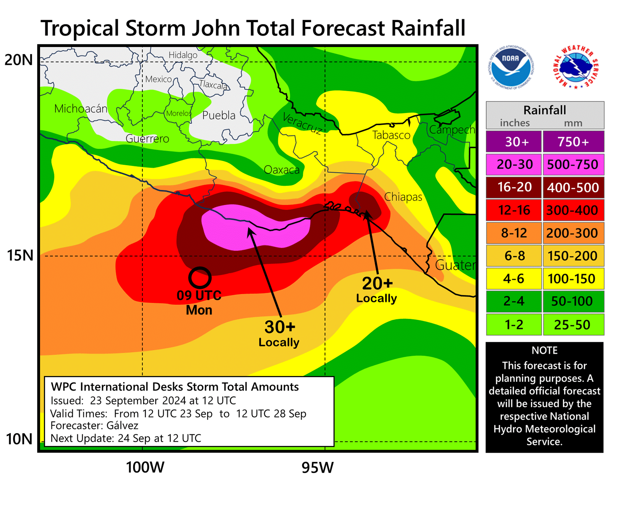
The rainfall forecast for Mexico's southwest Pacific coast as Hurricane John makes landfall, Sept. 24, 2024, from the Weather Prediction Center at the National Oceanic and Atmospheric Administration. NOAA
Source
|